West Coast Road is a vital travel artery. It connects Greater Victoria to the far-end reaches of Port Renfrew and beyond, along it, countless natural wonders await curious visitors from far away.
Wondrous as it may be, however, the road is also exposed to the harsh terrain and natural and unnatural elements, such as seismic activity, the combined weight of hundreds of logging trucks, and the erosion by wind and sea.
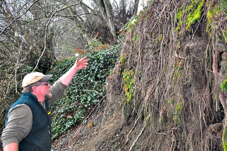
Such is the case of the stretch crossing King Creek, a place of childhood memory for Otter Point resident Al Wickheim.
In the last decade, the road has become a cause of concern for Wickheim, who believes the bank at the bottom is being rapidly eroded by the tides, potentially risking the road’s collapse.
“If we get a southeasterly coming through here at high tide, we could wake up in the morning and this will be gone,” he said.
“Not only is the infrastructure is going to go, but it will be one of those news stories where somebody drives into a big hole in the middle of the road.”
Way back a 100 years ago, there was no West Coast Road going through, just a grassy beach at the bottom. In the 1930s, when the road was built, a bridge was implemented to connect the west with the east.
Wickheim recalled the bridge was “rickety” and didn’t last long, so a culvert was later put in over King Creek, filling the rest with pit run gravel.
This, Wickheim said, is where the trouble began.
“There’s no structural material there other than fill,” he said, explaining the bank angle of repose — a slope that a fluid will take naturally, something which gravel is known to do.
“The angle of repose to that slope will mean that three feet inwards, it will drop down to find its angle of repose, because that’s what it wants to do. It’ll keep eating away at the bank.”
And it has.
Wickheim pointed towards a former trail with steps that led from the top of a fire hydrant to the bottom of the beach; the trail is now gone, replaced with dozens of trees that have tilted downwards, pulling more of the bank with them.
Despite Wickheim’s concerns, the Ministry of Transportation and Infrastructure sees the matter in a less severe light.
“At this time, there are no concerns regarding the safety of the travelling public on this section of Highway 14,” said Sonia Lowe, a spokesperson for the Ministry of Transportation and Infrastructure.
“With the safety of the public our highest priority, ministry staff will continue to actively monitor the site and will undertake additional technical work to develop a long-term solution.”
Lowe, added that ministry staff is aware of concerns about the erosion at this location and has done a preliminary assessment.
Still, Wickheim believes the matter is not only concerning, but preventable, at least at this point.
“All they have to do is ditch this down about six feet deep, fill it with a couple of rows of big boulders to about halfway,” he said.
“The fix here is not cheap, but it’s easy, and it’ll prevent a more serious problem.”