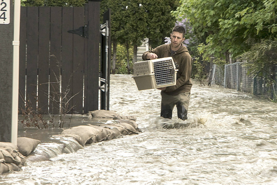
Nearly 2,700 people have been ordered to evacuate their homes in British Columbia’s southern Interior as officials warn of flooding due to extremely heavy snowpacks, sudden downpours and unseasonably warm temperatures.
Chris Marsh, emergency operations centre director and program manager for the Regional District of Kootenay Boundary, said there has been ”significant flooding” in the eastern area of the region.
“Over the last 24 to 36 hours we’ve experienced significant rainfall, up to 50 millimetres in some spots and in some of the drainages in this area, and that’s caused the rivers to rise significantly over the past 24 hours,” Marsh said Thursday.
Frances Maika of the regional district said the flood is “in the range” of a once in a 200 year occurrence.
Evacuation orders were issued Thursday for the about 1,500 properties covering a large area along the Granby, Kettle and West Kettle rivers, as well as in the Carmi region, 80 kilometres southeast of Kelowna.
Related: Evacuation orders issued for 2,500 in B.C.’s Kootenay-Boundary region
Related: ‘Out of control’: Flood evacuates 54 Okanagan Falls properties
Officials in Osoyoos declared a state of emergency Thursday evening due to the “imminent threat of flooding and rising lake levels.” They also ordered the Coast Hotel to be evacuated due to an “immediate danger to life and safety.”
Related: Evacuation Order has been issued for the Osoyoos Coast Hotel
Related: Highway 3 west of Keremeos to remain closed
Marsh said there have been washouts on smaller streams and tributaries in the region as well, isolating residents on some properties.
Marsh said they expected water levels to peak Thursday evening, adding that different parts of the district could see bodies of water swell between 30 and 100 centimetres.
“If you are thinking you’re safe because you haven’t flooded before, but you are seeing the water come up, please make sure you’re safe and that you make the decision timely enough to evacuate yourself if you need to.”
Jessica Mace of the Kettle River Watershed Authority said volunteers arrived in downtown Grand Forks from across the area to help business owners and residents.
“It’s been truly amazing,” she said. “I was just downtown and there are tons of people down there helping all the businesses sand bag their places as best they can.”
Mace and Maika said volunteers had filled almost 30,000 of the 120,000 sandbags that went out.
“Many businesses are starting to donate food,” said Mace. “People are very happy to see food show up.”
Residents under evacuation order are being directed to reception centres in Grand Forks and Midway, but Maika said the surge of water should pass quickly.
“In the next 24 hours, we are going to see the peak in some areas but then people have to respond to what has happened. The recovery is going to be an active process,” she said.
The EmergencyInfoBC website, which provides information during provincial emergencies, lists evacuation orders or alerts in seven regional districts and for seven First Nations around the province.
The province also encouraged local governments and First Nations communities along the lower Fraser River to prepare for potential flooding as it experiences high flow rates. Average temperatures in the region have been five degrees above normal for the last two weeks, and higher temperatures are forecast for next week, it said in a news release.
The Central Okanagan’s emergency response centre said there had been localized flood and record creek flows in the area including Kelowna. Mission Creek reached a record flow rate overnight on Wednesday, the centre said, and dikes, sand bags and tiger dams were able to contain the flow.
Related: Joe Rich residents displaced by floods
Related: More flood erosion on Princeton Summerland Road
— By Spencer Harwood and Beth Leighton in Vancouver
The Canadian Press