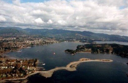
Whiffin Spit does not look much different than it does to the hundreds of walkers who today enjoy the walking trail every day. Thepicture was taken by Joe Titus in 1996.
According to a map given to the Sooke Region Museum by the Naval Museum in Madrid, Spain, the spit did look quite different in June 1790 when the Sooke inlet was charted by Manuel Quimper on his voyage of discovery for Spain in the Princesa Real.
Quimper was greeted by the T’Sou-ke people. Quimper’s log records: “Day dawned with the sky clear and the land all covered with mist and the wind calm … three canoes of Indians came out from the port and insisted we should go in … and it was very good.”
The 1996 view of the spit shows a slender promontory with a few wider sections, but the 1790 chart from Madrid shows the entrance to Sooke Harbour protected by a much broader and solid looking piece of terrain.
Even though there was once a sturdier peninsula, we did learn from folks back when we started the museum, that there were times that high tides in the 19th century would run over the neck of the spit and ships sailed over it.
While we understand that the First Nations once had lookouts at the spit, after the European immigrant population began settling in 1849, it wasn’t long before the spit was taken into use for industrial purposes.
One of the most significant of these was the storage of fishtraps pilings after the fishtraps industry had begun in 1904.
The tall Douglas-fir pilings for the traps were driven into the ocean floor each spring by pile-driver, and withdrawn again in the fall.
The piles were then stored in criss-cross fashion in great piles on the wider portions of the spit so that the wind would blow through them and keep them from deteriorating over winter. The last year of the fishtraps operation was 1958.
During the 1920s, the Bible Student colony that established itself near the highway corner of Whiffin Spit Road initiated a fish reduction plant on the farthest wide section of the spit.At the far end, when you’re walking, if you notice apple trees in bloom in spring, they date back to the retired whaler who had a cabin on the spit early in the 1900s.
•••
Elida Peers is the historian of the Sooke Region Museum. Email historian@sookeregionmuseum.com.
editor@sookenewsmirror.com
Like us on Facebook and follow us on Twitter